Description of the nominated property
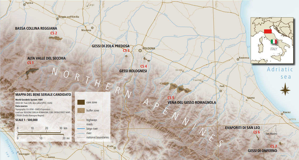
This is a serial site composed of 7 areas located in the provinces of Reggio Emilia, Bologna, Ravenna, and Rimini
The nominated property extends over a territory consisting of 7 component sites. It surrounds the entire straight ridge of evaporite outcrops that emerges on the northern slopes of the Apennines, from the “Vena del Gesso Romagnola” to the Secchia River Valley, which exposes, by erosion, some older evaporite deposits. The boundaries of the nominated property extend also underground, to include the cavities produced by karst phenomena.
All the major known caves in evaporites are included in the nominated property and are protected by Regional, National and International laws.
This is a serial site composed of 7 areas located in the provinces of Reggio Emilia, Bologna, Ravenna, and Rimini.
The name “Evaporitic Karst and Caves of the Northern Apennines” (EKCNA) was chosen to represent the geological value and emblematic characteristics of karst phenomena and to provide an easy and immediate geographical context, as the Apennines are the mountain range of the Italian peninsula known and studied internationally.
As a whole, the site comprises 7 distinct areas (called buffer zones). Within the buffer zones, there are 9 core areas (the so-called component sites), which constitute the actual World Heritage Property. These nine sites represent the most complete, extraordinary, and accessible examples of karst phenomena in gypsum and anhydrite under humid subtropical climatic conditions.
Located in northern Italy (within the provinces of Reggio Emilia, Bologna, Ravenna, and Rimini), this serial property showcases various types of mineralogical evolution of gypsum, including its transformation into anhydrite and alabaster, as well as many speleothems and minerals that are unique to this area, thanks to a complex interplay of rocks, geological evolution, and climate.
The 7 distinct areas are identified as follows:
1. i Gessi triassici dell’Alta Valle Secchia (component site CS.1)
2. i Gessi della Bassa Collina Reggiana (CS.2)
3. i Gessi di Zola Predosa (CS.3)
4. i Gessi Bolognesi (CS.4)
5. la Vena del Gesso Romagnola (CS.5a M.te Penzola, CS.5b M.te del Casino, CS.5c M.te Mauro)
6. le Evaporiti di San Leo (CS.6)
7. i Gessi di Onferno (CS.7)
The boundaries of the property take into account the extent of the entire karst system (both surface and underground), including the water circulation paths and the recharge basin. Particular care was taken to include all historical study areas, due to the significant role these locations have played in the development of speleology, mineralogy, and hydrology in evaporitic contexts.
All areas share the presence of rocks formed through the evaporation of marine waters that once covered these regions, along with the consequent deposition of mineral salts, including gypsum.
In fact, this serial site includes over 90% of the evaporitic rock outcrops in the Emilia-Romagna region and hosts, thanks to its unique geological and climatic setting, a density of surface karst forms, caves, saline springs, minerals, speleothems, and paleontological contents that is unmatched anywhere in the world.
Due to their accessibility and proximity, these phenomena have been studied since the 16th century, and many modern scientific theories on evaporitic karst were born here. It is a site of extraordinary value—not only geological and geomorphological, but also paleontological, biological, archaeological, and art-historical.
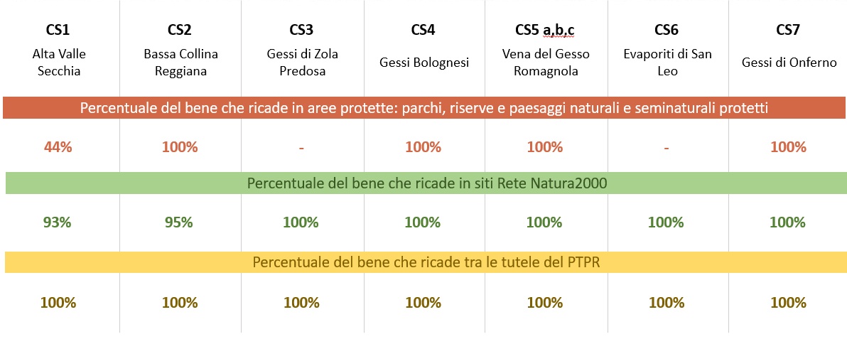
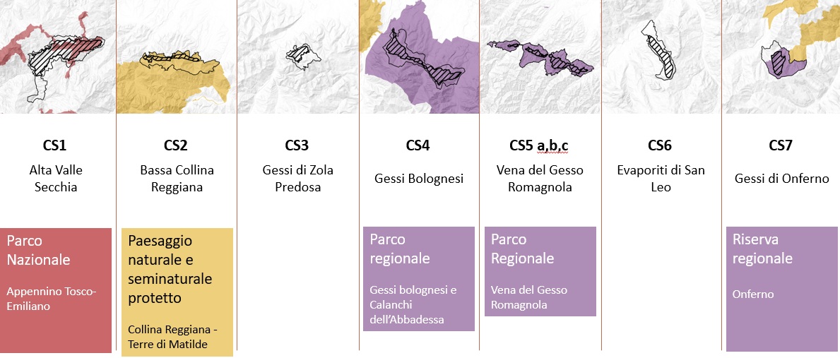
Most of the property falls within protected areas, specifically the Tuscan-Emilian Apennine National Park, two Regional Parks (the Gessi Bolognesi Park and the Vena del Gesso Romagnola Park), and the Onferno Nature Reserve.
The remaining areas are protected by European Community directives, as well as national and regional laws (Rete Natura 2000, Protected Landscapes, etc.). All sites are officially catalogued by the Emilia-Romagna Region as geosites under Regional Law No. 9/2006 "Regulations for the conservation and promotion of geodiversity in Emilia-Romagna and related activities."
The core areas (highlighted with dashed lines) of 5 of the 7 component sites fall within protected areas managed by specific authorities:
- Alta Valle del Secchia – managed by the Tuscan-Emilian Apennine National Park authority, as it falls within the National Park;
- Bassa Collina Reggiana – managed by the Central Emilia Parks and Biodiversity Management Authority, as it falls within the “Collina Reggiana – Terre di Matilde” Protected Landscape;
- Gessi Bolognesi – managed by the Eastern Emilia Parks and Biodiversity Management Authority, as it falls within the Gessi Bolognesi and Calanchi dell’Abbadessa Regional Park;
- Vena del Gesso Romagnola and Gessi di Onferno – managed by the Romagna Parks and Biodiversity Management Authority, as they fall within the Vena del Gesso Romagnola Regional Park and the Onferno Nature Reserve, as shown in the image below.
In addition to the protected areas, other protection instruments cover the core zones, such as Rete Natura 2000 sites and the Regional Landscape Plan (PTPR), as shown in the following table.
Rete Natura 2000 represents a common thread in the protection of the serial property, covering over 96% of its total surface area.